


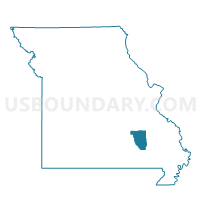
Oates Voting District, Reynolds County, Missouri
About
Outline

Summary
| Unique Area Identifier | 609544 |
| Name | Oates Voting District |
| County | Reynolds County |
| State | Missouri |
| Area (square miles) | 30.14 |
| Land Area (square miles) | 29.76 |
| Water Area (square miles) | 0.39 |
| % of Land Area | 98.72 |
| % of Water Area | 1.28 |
| Latitude of the Internal Point | 37.55565840 |
| Longtitude of the Internal Point | -91.07507820 |
Maps


Graphs
Select a template below for downloading or customizing gragh for Oates Voting District, Reynolds County, Missouri


Neighbors
Neighoring Voting District (by Name) Neighboring Voting District on the Map
- Black Voting District, Reynolds County, MO
- Bunker Voting District, Reynolds County, MO
- Centerville Voting District, Reynolds County, MO
- Viburnum Voting District, Iron County, MO
Top 10 Neighboring County Subdivision (by Population) Neighboring County Subdivision on the Map
- Carroll township, Reynolds County, MO (1,314)
- Dent township, Iron County, MO (1,194)
- Black River township, Reynolds County, MO (594)
Top 10 Neighboring Elementary School District (by Population) Neighboring Elementary School District on the Map
Top 10 Neighboring Unified School District (by Population) Neighboring Unified School District on the Map
- Iron County C-4 School District, MO (2,879)
- Bunker R-III School District, MO (1,547)
- Lesterville R-IV School District, MO (1,295)